New Website Visualizes Human Activity in Cities Across the World

By Karissa Rosenfield

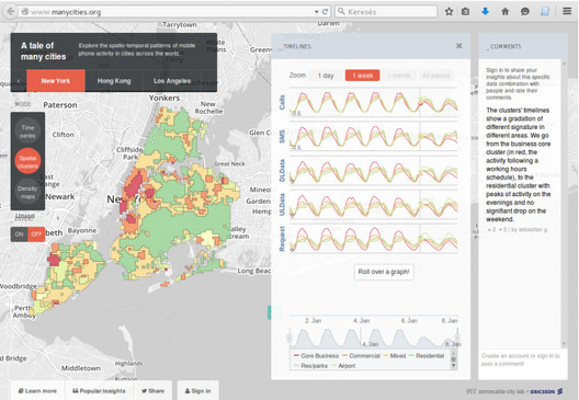
Screenshot of ManyCities, showing clusters of New York areas with similar timeline patterns. Image © ManyCities

Screenshot of ManyCities, showing clusters of New York areas with similar timeline patterns. Image © ManyCities

The SENSEable City Laboratory at MIT has developed a new tool with Ericsson to better understand human behavior. “ManyCities” is a new website that “explores the spatio-temporal patterns of mobile phone activity in cities across the world,” including London, New York, Los Angeles and Hong Kong. Taking complex data and organizing it in a intuitive way, the application allows users to quickly visualize patterns of human movement within the urban context down to the neighborhood scale. You can imagine how useful a tool like this can be for urban planners or even daily commuters, especially once real time analytics come into play. Take a look at ManyCities yourself, here.


Screenshot of ManyCities, showing timelines of mobile phone activity in different districts of London. Image © ManyCities

Screenshot of ManyCities, showing the density of SMS activity in different districts of Hong Kong. Image © ManyCities

Source:: http://feedproxy.google.com/~r/ArchDaily/~3/wSCo-S0eIEc/new-website-visualizes-human-activity-in-cities-across-the-world

Subscribe
Notify of
guest
0 Comments
Inline Feedbacks
View all comments